


Tracing the Fragmentation of a country:
The Balochistan region, which spans across parts of Iran, Afghanistan, and Pakistan, has a long and complex history of political and territorial disputes. This report aims to provide a comprehensive overview of the partition of Balochistan between 1795 and 1948, which saw various parts of the region being divided and annexed by different colonial powers and states.
The report will analyze the different treaties, agreements, and conquests that led to the partition of Balochistan. It will also examine the reasons why Baloch Nationalists observe 27 March as a black day, marking the annexation of Kalat, the largest Baloch state, by the newly formed state of Pakistan.
In addition, the report will feature historical maps of the region and provide detailed explanations of each dissection of Balochistan, including the territories that were ceded to the British, the Persian, and the Afghan Empires, as well as those that were later incorporated into Pakistan.
Overall, this report aims to shed light on the complex and often overlooked history of the partition of Balochistan, and to provide insights into the ongoing political and social struggles of the Baloch people in the region.
Additionally, the boundary representation is not necessarily based on authoritative data.
Derajat’s Journey from Kalat to Pakistan
“DeraJat is a region located mostly in modern-day Pakistani Punjab, encompassing the areas of Dera Ghazi Khan, Dera Fateh Khan (Tunsa), Rajhanpur, parts of Bakkar and Layyah, parts of Rahim Yar Khan, Dera Ismail Khan, Tank in KPK and bordering areas of Balochistan and Sindh Province. Despite being smaller than other Baloch areas, it is one of the most densely populated Baloch areas. The earliest Baloch settlement in this region can be traced back to the 15th century.
From 1717 to 1795, the Derajat’s Dodai Federation was under the jurisdiction of the Khanate of Kalat. However, in 1795, the neighboring Afghans attacked the federation and took control of it for over 20 years. The unstable state of Kalat led to the Baloch tribals resisting against the Afghan control.
In 1819, the Afghans were badly defeated by the Sikh Empire and forced to surrender many Afghan lands, including the occupied Derajat areas. Due to the consistent resistance by the Baloch people, the Sikhs were limited to cities and forts, while the rest of the Derajat was controlled by Baloch fighters. This continued until 1839 when the Sikhs were defeated by the British forces with the help of Baloch tribes.
After the British defeated the Sikhs, they gained control of the region. In 1849, the British Empire divided the region into two districts, Dera Ghazi Khan, and Dera Ismail Khan. Later, when Pakistan was formed in 1947, the region of Derajat became a part of Pakistan.
Following the partition of the subcontinent, some parts of Derajat were distributed to other provinces of Pakistan. Certain areas were added to what is now Khyber Pakhtunkhwa province, Sindh and Balochistan provinces, while most of Derajat’s area was eventually incorporated into the Pakistani Punjab province in 1970.”
The Eastern and Western Balochistan Line
The Eastern and Western Balochistan Line is a boundary that separates parts of Iran and Pakistan. It was established in 1871 and formalized in 1903 and 1905 through two arbitrary delineations – the Gold Smid Line and the Holds arbitrary. The Gold Smid Line runs from the Koh-e-Siahan region to the Gwadar Bay, while the Holds arbitrary was defined by Sir Thomas Holdich from Koh-e-Malek Siah to Koh-e-Siahan. The line led to the territorial reorganization of Western Balochistan in 1938, dividing it into four provinces. Sistan va Balochistan was one of the newly created provinces, and parts of western Balochistan were merged into Kerman, South Khorasan, Hormozgan, and small part in to Razavi Khorasan.
These boundaries and the subsequent territorial reorganization reflect the complex history and geopolitical forces at play in the region. Today, the Eastern and Western Balochistan Line remains a significant marker of the boundary between Iran and Pakistan, affecting the political, economic, and social dynamics of the region.
In 1959, Pakistan handed over Mirjaveh and other border areas to Iran, resulting in a minor adjustment of the Balochistan borders between the two countries. This transfer of territory reflected diplomatic efforts to improve relations between Iran and Pakistan.
Additionally, the boundary representation is not necessarily based on authoritative data.
The Baloch-Afghan-Persian Border:
Historical Context and Disputed Territories
The Baloch region was divided into southwestern and eastern/western regions through three treaties:
A series of third-party arbitrations between 1872 and 1935 formalized the Iran-Afghanistan border, originating from the Treaty of Paris signed in 1857.
The McMahon Award established the Afghanistan-Iran border in the Baloch region in 1903 and 1905.
The Durand Line was established in 1893, separating Afghanistan and what is now Pakistan, but its legitimacy remains disputed. In 1896, a re-adjustment of the border in Baloch areas occurred due to Afghan Ameer’s non-compliance with the Durand Treaty. The McMahon Line, which dissects the Baloch regions between Afghanistan and Pakistan, was established as part of this re-adjustment. However, most Baloch historians and writers consider the McMahon Line separate from the Durand Line.
In 1929, the Baloch areas were merged into the provinces of Farah and Kandahar, and later reorganized into four provinces: Nimroz, Kandahar, Farah, and Helmand, in 1968. The disputed legitimacy of the Durand Line poses a significant challenge for the region’s stability and security.
Karachi, Khangarh, Gwadar, Mirjaveh
Karachi has a long history of Baloch population, with their presence being traced back to the long before first Arab invasion of Sindh. The village of Karachi was under different rules, from being a part of Makran to being under various regional powers. In 1666, under the rule of Mughal Emperor Aurangzeb, it was handed over to the ruler of Kalat in Balochistan. However, control over Karachi changed hands to another Baloch ruler, the Talpurs. In February 1839, the British forces took control of the port town, which led to negotiations between the British and Kalat before the first Anglo-Afghan War. One of the pre-conditions for negotiations was the restoration of Khan’s control over Karachi, but the negotiations ultimately failed, and the British attacked Kalat.
The British occupation of Balochistan began before the attack on Kalat by British Indian forces. One of the regions that had already fallen under British occupation was the remote village of Khan-Garh, now known as Jacobabad-Jekmabad, which was conquered between 1839 and 1840. The strategic military importance of Khan-Garh played a significant role in the British expansion into the region.
In 1783, Gwadar was granted to Said bin Ahmad by Noori Naseer Khan, as a gesture of Baloch tradition of offering refuge. For over a century, it remained under the rule of Oman as part of its overseas holdings, serving as a strategic port and a hub of maritime trade. It was in 1958 that Gwadar was finally integrated into Balochistan.
In 1959, as part of a border agreement, General Ayub Khan, the President of Pakistan at the time, ceded parts of Mirjaveh and other border areas to Iran as a gift. This agreement was known as the “Gwadar-Tehran Declaration.”
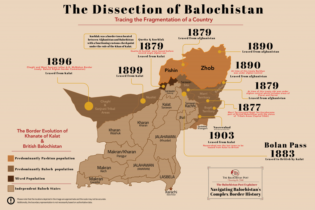
British Balochistan
Leased Areas from Balochistan (Kalat) and Afghanistan
In 1879, before the Second Anglo-Afghan War, Quetta and Kuchlak were leased from Kalat. In the same year, Pishin and Sibi were leased from Afghanistan. The areas surrounding Sibi were also pleased with the same arrangement, including Harani and Ziarat. It’s worth noting that Sibi changed hands on multiple occasions between Afghanistan and Balochistan, but it was predominantly a Baloch area since the 1500s.
After a rebellion in the Mari and Bugti regions, the British government brought an end to the unrest through a treaty in 1877. As a result, tribal status was granted to these areas.
In 1883, the Bolan Pass tracts were leased to the British by Kalat. In 1890, Zhob and the territory of Khetran tribe were leased from Afghanistan. At the time, Khetran territory (Barkhan) was under Afghan administration, but it’s a Baloch native area.
In 1896, Chaghi and West Sanjrani tribal areas were leased after the A.H. McMahon Border treaty – Baloch Afghan border Commission. In 1899, Nushki was leased from Kalat. Lastly, in 1903, Naseerabad was leased from Kalat. It was the last area to be leased from Kalat to British India, and the city was named after Noori Naseer Khan.
In 1947, these leased areas of British Balochistan joined Pakistan. However, in 1955, it was disestablished.
Additionally, the boundary representation is not necessarily based on authoritative data.
Balochistan’ s Annexation History.
In 1839, the British launched an attack on the Khanate of Kalat, resulting in the deaths of around 300 people, including the ruling Khan Mehrab Khan. The British occupation of Kalat aimed to subjugate Balochistan, leading various tribes to unite under the leadership of Mir Naseer Khan II. Although the Baloch tribes were successful in liberating the Khanate in 1841, the British-imposed conditions limited their independence.
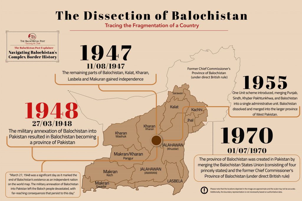
Over the next century, the British gradually annexed parts of Balochistan to Afghanistan and Iran, creating the British Balochistan province. In August 1947, Balochistan gained independence from British rule, with the remaining region consisting of Kalat, Kharan, Makran, and Lasbela. However, on 27 March 1948, the Khanate of Kalat was forcibly incorporated into Pakistan, and Balochistan became a province of Pakistan.
In 1952, the Balochistan States Union was formed by merging the Kalat, Kharan, Lasbela, and Makran states, In 1955, Pakistan introduced the One Unit scheme, which merged the provinces of West Pakistan including The Balochistan State Union into a single administrative unit. This move dissolved Balochistan, along with other provinces, and merged them into the larger province of West Pakistan.
In 1970, the province of West Pakistan was dissolved, and the present-day province of Balochistan was created by merging the former Balochistan Province (which was the former Chief Commissioner’s Province of Balochistan under British rule) and the former Balochistan States Union (consisting of four princely states).
The Potential of a Reunited Balochistan
If Balochistan were to become an independent country again, it would possess a landmass of approximately 731,000 square kilometers, making it twice as big as Germany, Japan, or Italy. Additionally, the region boasts a coastal line of 1,100 kilometers, which would grant it a strategic advantage in terms of maritime trade. Balochistan’ s location, bordering the Indus River to the Middle East and the Indian Ocean to the gateway of Central Asia, would further amplify its significance as a potential trade hub.
Furthermore, Balochistan is rich in natural resources, including oil, gas, and minerals, which could fuel its economic development. The region’s rugged terrain is ideal for tourism, with many areas yet to be explored and discovered. Additionally, Baluchistan’s strategic location could serve as a gateway for transportation and energy corridors, connecting the Middle East, Central Asia, and South Asia.
In conclusion, if Balochistan becomes a country again, it has enormous potential for growth and development. With its vast landmass, abundant natural resources, and strategic location, the region could become a major player in regional and global affairs.